
Astronomy: Sun & Moon / Sky Map & Clear Sky Chart / NASA Satellite Earth View
Script Provided by 
Day Length: There will be 1min 42s more daylight tomorrow.
CURRENT MOON PHASE
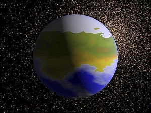
NASA SATELLITE EARTH VIEW
These new Global Views and Animations of Earth’s City Lights is a Composite assembled from Data acquired by the Suomi NPP Satellite.
The Data was acquired over 9 Days in April 2012 and 13 Days in October 2012. It took 312 Orbits to get a Clear Shot of every Parcel of Earth's Land Surface and Islands
Credit: NASA Earth Observatory/NOAA NGDC
Satellite Video 'Earth Lights' Provided by NASA Earth Observatory & Goddard Space Flight Center
In Daylight, our Big, Blue Marble is all Land, Oceans and Clouds...
The Night, on the other hand, is Electric. This Video provides a Tour of some Highlights of the 'New Suomi NPP Earth at Night' Imagery.
Credit: NASA's Goddard Space Flight Center
ASTRONOMY INFORMATION
Explanation 'Sky Map'
| Sky Map: | Horizon Views: |
|---|---|
| The Sky Map shows the Entire Sky as Viewed (South) from the Altona Forest Weather Station's Location. The Limiting Magnitude is the Faintest Apparent Magnitude of a celestial body and frequently refers to the Faintest Stars that can be seen with the unaided eye on a clear Moonless night. On the 'Sky Map', the Limiting Magnitude is set to 4.0 which corresponds to roughly 250 visible Stars | Horizon Views is showing the Stars above the Horizon as seen from a Specified Observing Site (Ridge Run Weather Station). The Viewing Direction (azimuth) is set to 180° (SOUTH) as Cardinal Point on the Compass with a Field of View of 75° |
| Observing Site: | Viewpoint: |
| The Sky View Depends on where you're standing on the Earth. The Sky Map uses the Latitude and Longitude Coordinates of the Weather Station's Location in West Bend, Wisconsin. Coordinates: 43°25' North and 88°12' West | The azimuth Specifies the Direction of looking towards the Horizon. The Viewpoint on the Sky Map is set to South 180° with a Field of View of 45° |
Sky Map above Ridge Run Neighborhood, Wisconsin (43°43.421312'N 88°211502'W)
Sky Map Provided by John Walker, Fourmilab - Switzerland
| HORIZON VIEW (FOV=75°) | PLANET POSITIONS |
|---|---|
| Azimuth 180° (South) Field of View 60° | Planet Locations (Mercury to Mars) in the Solar System |
| An azimuth is the measurement of the position of a star in the sky. The star is the point of interest, the reference plane is the horizon, and the reference vector points to the North or South. The Azimuth is the angle between the North or South vector and the perpendicular projection of the star down onto the horizon | The ecliptic is defined as the plane containing the Earth's orbit. With respect to that plane, the other orbits are inclined and thus, in the course of each revolution the planets rise above and fall below the plane of the ecliptic. The portion of the orbit above the plane of the ecliptic is drawn in blue, the portion below in green. |
Sky Map above West Bend, WI
Sky Map Provided by AstroViewer
CLEAR SKY CHART
(Mt. Lemmon Observatory (AZ))
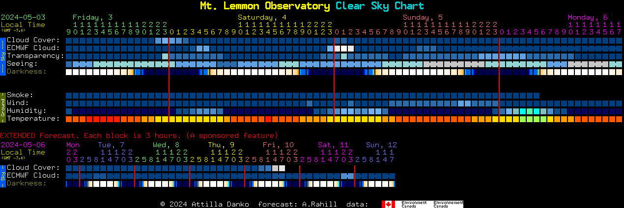
Clear Sky Chart Provided by ClearDarkSky.com
CHART LEGEND:
Summary: In the Rows labeled "Sky Conditions", find a Column of Blue Blocks. You can probably Observe then.
CLOUD COVER
The line, labeled Cloud Cover forecasts total cloud cover. The colors are picked from what color the sky is likely to be, with Dark blue being clear. Lighter shades of blue are increasing cloudiness and white is overcast.
![]()
TRANSPARENCY
The line, labeled Transparency, forecasts the transparency of the air. Here 'transparency' means just what astronomers mean by the word: the total transparency of the atmosphere from ground to space. It's calculated from the total amount of water vapor in the air.
![]()
SEEING
The line, labeled Seeing, forecasts astronomical seeing. (It's an experimental forecast.) Excellent seeing means at high magnification you will see fine detail on planets.
![]()
DARKNESS
The line labeled darkness is not a weather forecast. It shows when the sky will be dark, assuming no light pollution and a clear sky.
![]()
Sunlight-Darkness View above 32°23'N 110°50'W (El Gheko Neighborhood, Arizona)