Updated: @ Dec-24-2023 4:30am - next update at 4:37am  
Summary / Temperature Wind Rain Outlook
Clear Clear
Currently: 41.2, Max: 41.2, Min: 40.9 41.2°F
Warmer 0.1°F than last hour.

Cold

Feels like: 41°F

24-hr difference
2.5°FWarmer 2.5°F than yesterday at this time.
  Today Yesterday
High: 41.2°F
4:26am
44.3°F
2:17pm
Low: 40.9°F
12:00am
37.8°F
6:27am
 Calm ---
0
Gust:
0 mph
0 Bft - Calm
Today: 0 mph 12:00am
Gust Month: 0 mph December 1
Rain Today: 0.00 in
Rain Rate (/hr): 0.00 in
Rain Yesterday: 0.00 in
This Month: 1.02 in
Season Total: 43.95 in
134 days since last rain.
Tonight

Tonight: Rain Showers Likely
Rain Showers Likely
Humidity & Barometer Almanac Moon
Humidity: 97 %  
Dew Point: 40.4°F Increased 0.2°F since last hour.
Barometer: 30.286 inHg  
Baro Trend: Falling slowly
Sunrise: 7:24am
Sunset: 4:21pm
Moonset: 5:12am
Moonrise: 2:19pm
Waning Gibbous
Waning Gibbous, Moon at 21 days in cycle
93
Illuminated
UV Index Forecast UV Index Forecast
   None
   None
 NWS Weather Forecast  - Outlook: This Afternoon & Tonight
This
Afternoon
This Afternoon: Sunny
Sunny

Hi 67 °F
NWS forecast: Sunny, with a high near 67. Southwest wind around 5 mph.
Davis VP+ forecast: Increasing clouds with little temperature change. Precipitation possible within 24 to 48 hours
 
Tonight

Tonight: Rain Showers Likely
Rain Showers Likely

Lo 54 °F
NWS forecast: Rain showers likely between 10pm and 1am, then showers and thunderstorms likely between 1am and 5am. Mostly cloudy, with a low around 54. South wind 5 to 15 mph, with gusts as high as 30 mph. Chance of precipitation is 70%. New rainfall amounts less than a tenth of an inch possible.
The Ridge Run Station website has been designated a "Weather Ready Nation" Ambassador! (08/12/2014)
WRN Ambassador Logo
To learn more on WRN, read this PDF document:
Pilot Projects Help Build a Weather-Ready NationTM
West Bend Cloudbase
cloudbase
NWS SKYWARN Storm Spotter Program
Weather.gov/skywarn

In most years, thunderstorms, tornadoes and lightning cause hundreds of injuries and deaths and billions in property and crop damages. To obtain critical weather information, the National Weather Service (NWS) established SKYWARNВ® with partner organizations. SKYWARNВ® is a volunteer program with between 350,000 and 400,000 trained severe weather spotters. These volunteers help keep their local communities safe by providing timely and accurate reports of severe weather to the National Weather Service.

Although SKYWARNВ® spotters provide essential information for all types of weather hazards, the focus is reporting on severe local thunderstorms. In an average year, the United States experiences more than 10,000 severe thunderstorms, 5,000 floods and more than 1,000 tornadoes.

Since the program started in the 1970s, the information provided by SKYWARNВ® spotters, coupled with Doppler radar technology, improved satellite and other data, has enabled NWS to issue more timely and accurate warnings for tornadoes, severe thunderstorms and flash floods. SKYWARNВ® storm spotters form the nation's first line of defense against severe weather. There can be no finer reward than to know that your efforts have given your family and neighbors the precious gift of time--minutes that can help save lives.

Who is eligible and how do I get started?

NWS encourages anyone with an interest in public service to join the SKYWARNВ® program. Volunteers include police and fire personnel, dispatchers, EMS workers, public utility workers and other concerned private citizens. Individuals affiliated with hospitals, schools, churches and nursing homes or who have a responsibility for protecting others are encouraged to become a spotter. Ready to learn more? Find a class in your area. Training is free and typically lasts about 2 hours. You'll learn:
  • Basics of thunderstorm development
  • Fundamentals of storm structure
  • Identifying potential severe weather features
  • Information to report
  • How to report information
  • Basic severe weather safety
Need help with your Spotter Number or other local information such as a missing class schedule? If you need help finding your spotter number or a class schedule, contact your local Warning Coordination Meteorologist. He or she can help you get, find or replace your spotter information and let you know about upcoming classes. Classes typically are held in an office's relatively slow season. Classes are NOT typically offered all year. Schedules vary from office to office.

Looking for our online program? You also can also take our free online spotter program. Some offices also ask that you take a local class to learn about weather unique to your area.

SKYWARN name and logo are trademarked: SKYWARNВ® is a registered trademark of NOAA's National Weather Service. Please read the rules for the usage of the SKYWARNВ® name and logo.
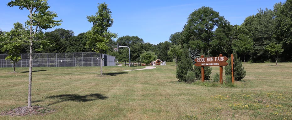
Ridge Run Weather Station's Affiliated Sites
Personnal Weather Stations  Citizen Weather Observer Program  www.awekas.at Community Collaborative Rain, Hail and Snow Network 
--- WEATHER TWEETS ---
CNN Weather Tweets
 
Weather Underground Tweets
 
New Earthquake Tweets
 
BBC Weather Tweets
 
USA Today Weather Tweets